There is a fishmonger on Salusbury Road. Not a supermarket fish counter. An actual fishmonger, someone who can tell you which sea your Dover sole came from and whether the mackerel is worth buying today. In 2026, in Zone 2 London, that's remarkable. It means the locals care enough about what they eat to walk past a Tesco and pay more. That single detail tells you nearly everything about Queen's Park.
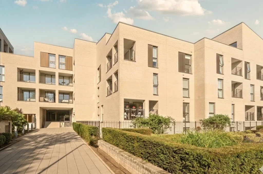
The name covers four things at once. A park: 30 acres of Victorian green space, Grade II listed, opened in 1887. A ward in the London Borough of Brent. A London Overground and Bakerloo line station. But mostly it's a state of mind, a name that attaches itself to everything within walking distance of those 30 acres. The postcode says NW6. The borough says Brent. Nobody who lives here introduces themselves by citing their council tax authority. They say Queen's Park.
To the west: Kensal Rise, more affordable, rougher at the edges, improving fast. To the south: Kilburn, with its buses and kebab shops and pubs where the Guinness is poured properly. To the north: Brondesbury Park, quieter, tree-lined avenues that feel closer to the suburbs than anything two miles from Paddington should. Queen's Park sits in the middle, borrowing from each without becoming any of them. Residential but not sleepy. International but not transient. The coffee is good, not because a chain did research, but because the locals would stop going to a place that served bad coffee, and the owners know it.
30 Acres That Define a Neighbourhood
Most London neighbourhoods are defined by a tube station or a high street. Queen's Park is defined by a park. That changes things.
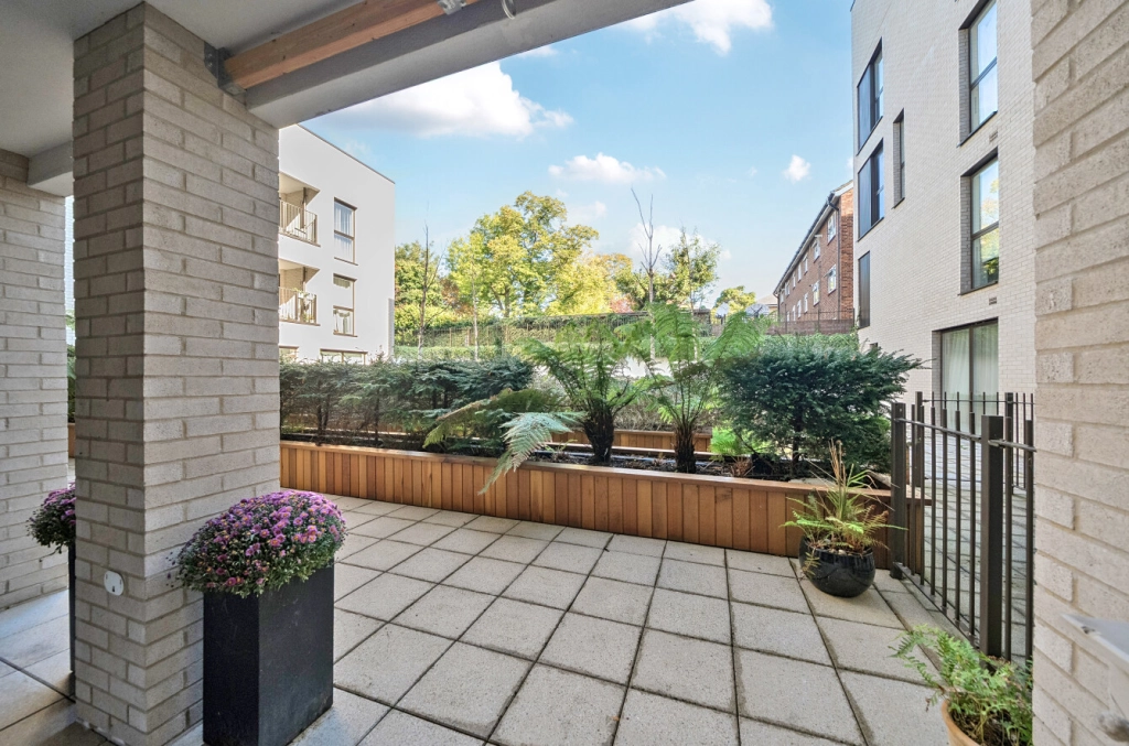
It opened in 1887, built on land from the Royal Agricultural Society's shows (Queen's Park, London). Thirty acres, large enough to lose sight of the surrounding streets once you're inside. The Corporation of London manages it, which is why it's maintained to a standard most Brent parks can't match. Six tennis courts. A pitch-and-putt. A children's paddling pool in summer. A small animal farm. A bandstand for weekend events. A cafe that has quietly become good.
But what matters is the daily rhythm. Weekday mornings belong to runners and dog walkers. By mid-morning, the parents and childminders arrive. Weekend afternoons are families, not the overwhelming Hampstead-Heath-on-a-bank-holiday kind, but the comfortable density of people who live nearby and treat the park as an extension of their garden. Sunday mornings are the farmers market crowd, spilling over from Salusbury Road with canvas bags and flat whites.
Thirty acres of green space within a 10-minute walk changes the maths of what you need. You don't need a garden, or at least, the absence of one stops being a dealbreaker. You don't need a gym membership when there are tennis courts for a few pounds. You don't need to drive your children to a play area when one is at the end of the road. The park is a shared amenity that increases the value of every home near it while costing the homeowner nothing. That's why proximity to Queen's Park has commanded a premium for decades.
| Detail | Info |
|---|---|
| Size | 30 acres, Grade II listed, opened 1887 |
| Managed by | Corporation of London (higher maintenance than Brent standard) |
| Facilities | 6 tennis courts, pitch-and-putt, paddling pool, animal farm, bandstand, cafe |
| Hours | Dawn to dusk (gated — closes at actual sunset) |
| Farmers Market | Every Sunday at the Salusbury Road entrance |
| From The Avenue | 10-minute walk |
Salusbury Road
The quickest way to judge a neighbourhood is its high street. How many of the shops are independent? Chains mean the landlords optimise for reliable tenants and the locals don't care enough to sustain anything distinctive. Independents mean the opposite: the locals have preferences, opinions about coffee, and willingness to pay slightly more for something specific. Salusbury Road is almost entirely independent.
Start at the southern end, near the park, and walk north. Milk Beach does brunch with the kind of seriousness that would be insufferable if the food weren't genuinely good. The Salusbury is a pub that also functions as a wine bar and a restaurant, and you can drink a pint of bitter at the bar on a Tuesday or eat a proper Italian meal in the dining room on a Saturday, and neither feels like a compromise. Parlour leans into natural wine with quiet confidence. Vijay's, the Indian restaurant that has been here for decades, survives not on nostalgia but because the food is excellent, the kind of place where you order the same dish every time.
Bob's Cafe does the full English with an integrity that phrase rarely deserves. The bookshop still exists, sustained by locals who'd rather buy a novel from a person who has read it than from an algorithm. A fishmonger. A butcher. A florist. A dry cleaner that knows your name after the third visit.
No Pret. No Costa. No Foxtons. The rents are high enough that only businesses with real local demand survive, but not so high that only chains can afford them. That equilibrium is rare in London and impossible to manufacture through planning policy. It emerges from the accumulated decisions of hundreds of residents who, day after day, choose to walk to the independent cafe instead of ordering from an app. The high street reflects the kind of people who live here.
No Pret. No Costa. No Foxtons. The rents are high enough that only businesses with real local demand survive, but not so high that only chains can afford them. That equilibrium is rare in London. Salusbury Road, Queen's Park
Queen's Park Farmers Market
Every Sunday, year-round, the Queen's Park Farmers Market sets up at the Salusbury Road entrance to the park. Everything sold is grown, reared, or produced within 100 miles, an audited standard, not a marketing claim. You buy from the person who grew the tomatoes or made the cheese. Sell bad produce and you see it in your takings the following Sunday. The feedback loop is immediate.
But the market does something harder to measure. You go to buy sourdough and you run into your neighbour. You stop for a coffee and end up in a 20-minute conversation about school admissions or the planning application on the next street. The market creates a weekly rhythm, a cadence to community life that most urban neighbourhoods have lost entirely. It's one of the most effective pieces of social infrastructure in north-west London, and nobody planned it that way.
| Detail | Info |
|---|---|
| When | Every Sunday, year-round, 10am–2pm |
| Where | Salusbury Road entrance to Queen's Park |
| Standard | Everything grown, reared, or produced within 100 miles (audited) |
| Pro tip | Arrive before 10:15 for the best sourdough |
Who Lives in Queen's Park
The question that matters about any neighbourhood isn't the buildings or the transport links. It's: who are the other people, and are they planning to stay? When people expect to remain in a place, they invest in it. They join the residents' association, support local shops, complain about fly-tipping instead of ignoring it, plant things in their front gardens. When they expect to leave, they do none of that. Queen's Park is a place where people stay.
The residents are predominantly professional, international, and established. There's a significant Jewish community, particularly closer to Brondesbury. French families, drawn partly by proximity to the Lycée and partly because Salusbury Road has the kind of food culture a French household considers non-negotiable. Media professionals, academics, architects, lawyers, people who work in central London but chose not to live there. The demographic is, honestly, affluent. Property prices in Queen's Park ensure that. (For a longer take on the daily rhythm, read our guide to what it's actually like living in Queen's Park.)
But affluence alone doesn't make a neighbourhood work. What makes Queen's Park function is that the affluence comes with engagement. The Residents' Association is active. The Friends of Queen's Park organise events. Parents are involved in schools beyond sports day. People recognise faces at the farmers market, nod at the dog walker on their street, know which neighbour to ask about a plumber. That texture of community can't be bought. It has to be built, over years, by people who care enough to build it.
The diversity is genuine but specific. Queen's Park isn't diverse like Kilburn. Kilburn has the range of a port city, every nationality and income bracket on the same high street. Queen's Park is diverse like an international school: wide range of nationalities, narrower economic band. Both have their merits. The point isn't to idealise either; it's to describe what actually exists so you can judge whether it's the community you want to join.
Conservation Area Status
The streets around Queen's Park carry formal protection, and it matters more than most buyers realise. In July 1986, Brent Council designated the Queen's Park Conservation Area, covering the Victorian grid between Salusbury Road and Chamberlayne Road, bounded by Harvist Road to the south and Chevening Road to the north. In 1993 it was extended westwards. Adjacent to the east, the Mapesbury Conservation Area (designated 1982) covers one of the largest protected residential zones in Brent, stretching up towards Cricklewood.
What this means in practice: you cannot rip out a Victorian sash window and replace it with uPVC. You cannot pave over a front garden without planning permission. You cannot fell or even prune a tree without notifying the council. Article 4 Directions, added in 1994 and 2004, tighten things further. They remove permitted development rights that would normally allow small alterations without planning consent. The result is that the streetscape you see today looks materially the same as it did thirty years ago. Front gardens still have hedges and brick walls. Bay windows are still original. Rooflines haven't been broken by clumsy loft conversions.
Of the 17 conservation areas still standing in the entire Borough of Brent, Queen's Park is one of the best preserved. Several former conservation areas elsewhere in the borough lost their status after Brent failed to enforce protections. Here, the Queen's Park Area Residents' Association (QPARA), active for over 40 years, monitors planning applications and challenges proposals that would damage the area's character. That kind of organised resident engagement is rare, and it works.
For buyers, conservation area status is a form of insurance. It means the house next door cannot become a house of multiple occupation overnight. It means the developer two streets away cannot add a storey without a fight. It means the qualities that attracted you to the area, the trees, the proportions, the front gardens, the quiet residential feel, are actively protected by law, not just by luck. Property in conservation areas commands a measurable premium precisely because of this. The streetscape holds, and values hold with it.
| Detail | Info |
|---|---|
| Queen's Park CA | Designated July 1986, extended 1993. Salusbury Rd to Chamberlayne Rd |
| Mapesbury CA | Designated December 1982. One of the largest in Brent |
| Article 4 Directions | Added 1994 & 2004 — extra controls on external alterations |
| Tree protections | All trees protected — six weeks’ notice required for any works |
| Resident oversight | QPARA active since 1980s, monitors all planning applications |
Transport from Queen's Park
Queen's Park station sits on the Bakerloo line (Paddington, Oxford Circus, Waterloo) and the London Overground Mildmay line (Gospel Oak to Stratford). Neither is the fastest line in London, but together they cover a lot of ground.
For many commuters, the more useful option is Kilburn station on the Jubilee line, a 9-minute walk from The Avenue. Bond Street in 10 minutes. Baker Street in 8. Canary Wharf in 25. Since the Elizabeth line opened, Paddington has become a more useful interchange too, about 8 minutes from Queen's Park station, with onward connections to Heathrow, Reading, and the West End without changing.
Brondesbury Park station, the closest to The Avenue at 4 minutes on foot, connects directly to Highbury & Islington, Hackney, and the wider Overground network. For anyone working in east London, such as Shoreditch and Dalston, this is the more relevant line.
Three stations within walking distance, serving three different lines. That kind of transport optionality is rare in Zone 2 and rarer still on streets this quiet. See the full transport guide for journey times and route options.
| Station | Details |
|---|---|
| Brondesbury Park (Overground) | 4 min walk from The Avenue |
| Kilburn (Jubilee line) | 9 min walk, Bond Street in 10 min |
| Queen's Park (Bakerloo + Overground) | 14 min walk |
| Paddington via Bakerloo | 8 min for Elizabeth line & Heathrow |
| Zone | 2 — three lines, no bus needed |
Schools Near Queen's Park
Schools are often the reason families choose Queen's Park, and the reason they stay. Malorees Infant and Junior School (Good, Ofsted) is a 2-minute walk from The Avenue. Salusbury Primary (also Good) is 10 minutes on foot and draws a genuinely mixed intake. The Convent of Jesus and Mary (Outstanding) is about 12 minutes' walk.
For secondary, Queens Park Community School is the local state option, and many families look to wider Brent and Camden offerings. Multiple bus routes and Overground stations make secondary access practical even when the school isn't on the immediate doorstep.
Distances, Ofsted ratings, and admissions notes are in the dedicated schools guide.
Queen's Park Property Prices
Property prices in Queen's Park follow a simple pattern: the closer to the park and Salusbury Road, the more you pay per square foot. Land Registry data shows NW6 prices ranging from £635 to £863 per square foot, depending on the street and property type.
Growth has been steady rather than spectacular: 21.9% over five years, 19.2% over ten. These are Land Registry figures (what people actually paid), not asking prices (what agents hoped for). The steadiness matters. Areas that surge tend to correct. Areas that grow consistently tend to hold.
One useful number: 38.4% of properties in the immediate postcodes are privately rented. That means strong tenant demand, which gives you an exit strategy. If you need to let rather than sell, you'll find tenants. It also means the area attracts people at different life stages, which keeps the neighbourhood balanced.
The Avenue sits at the northern edge of the Queen's Park catchment, close enough for the lifestyle, on a street quiet enough to forget you're in Zone 2. At £770 per square foot, it sits comfortably within the NW6 range. Whether that's value depends on what you compare it to. The full property price guide has the numbers.
| Metric | Figure |
|---|---|
| Price range | £635–£863 per sq ft across NW6 (Land Registry) |
| 5-year growth | 21.9% (Land Registry data) |
| 10-year growth | 19.2% |
| Rental demand | 38.4% of local properties privately rented |
| The Avenue | £770 per sq ft — mid-range for NW6 |
How Queen's Park Compares
Every neighbourhood looks different depending on what you compare it to. Queen's Park sits between several well-known areas, each with its own character, pricing, and trade-offs. These detailed comparisons examine what you gain, what you give up, and where the real differences lie.
- Queen's Park vs Kilburn — Village calm meets urban energy
- Queen's Park vs Kensal Rise — Similar vibes, different transport
- Queen's Park vs West Hampstead — Value versus premium
- Queen's Park vs Maida Vale — Community versus centrality
- Queen's Park vs Primrose Hill — Same lifestyle, different price tag
- Queen's Park vs Hampstead — North-west London's two villages
- Queen's Park vs Notting Hill — Before and after the fame